ARCHIVES
April 2009
January 2009
March 2008
February 2008
January 2008
December 2007
October 2007
August 2007
July 2007
May 2007
CONTACT
|
About this blog: random thoughts, discoveries, ramblings. Much of this was originally composed as email to a local history mailing list, rather than being written specifically for publishing, so it's a little disjointed. I figured it was better to get it out to everyone else in rough form rather than not at all.
If you have a common interest in anything, or can add further to the information I've provided here, please contact me. |
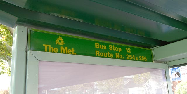
I was walking past a bus shelter in Carlton North and this caught my eye. It's not super old, but a sign saying "The Met" and featuring the three way logo is looking decidedly stale in 2009. I had my camera out so I snapped a quick shot, then kept walking.
Ten minutes later as I was returning to my car, I noticed someone changing the signs on the shelter to something more modern. The old sign was gone, literally minutes after I had taken a photo. Very lucky!
|
|
I was in the Aurora estate a couple of days ago to see what had changed. I drove right past an old homestead at first, thinking it had been demolished. When I turned around and looked more closely I realised it had melted into a sea of new houses.
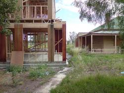
New buildings only metres away from a historic homestead. Can you say OVERDEVELOPMENT!!!!
|
|
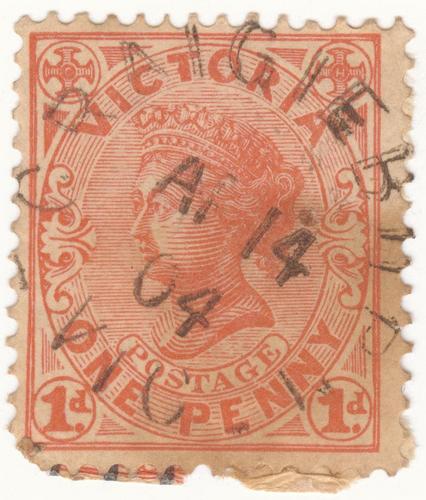
Saw this by chance on ebay, made a single bid, and won. A 108 year old piece of history in my hand.
|
|
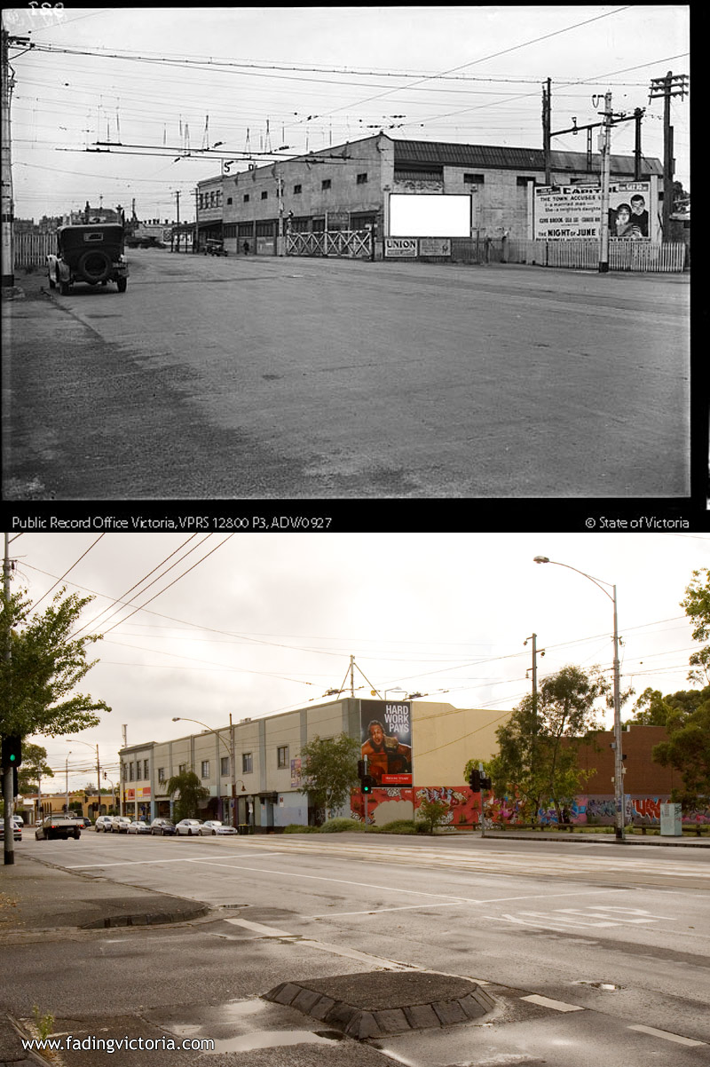
I saw a historical image on PROV earlier today, probably from around the mid 1920s to 1930s. Since I was heading into that area I took a current photo from a similar position. The train line, boom gates and overhead wiring are long gone, but the commercial buildings in the background are apparently older than their current facade would suggest...
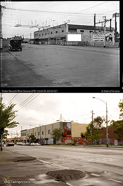
There is also another image of this location from a different year available at http://www.prov.vic.gov.au/images/12800/12800-p0003-000012-100.asp
|
|
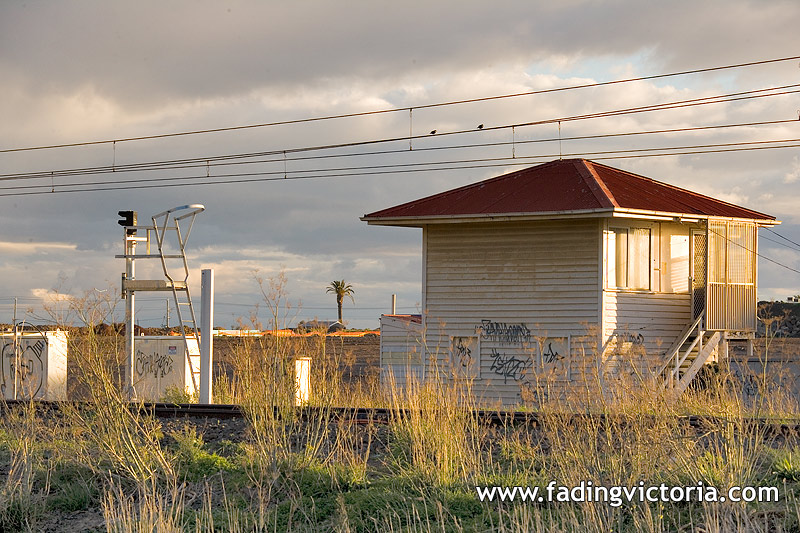
I noticed today that the signal box at Somerton (just south of Roxburgh Park station) has disappeared. I knew some time ago that it was going to be demolished - even though it is heritage listed - but because the Somerton Road railway overpass is pretty much complete I thought they'd found a way to preserve it. I guess I was wrong.
It's not the prettiest bit of infrastructure around, but it was working there for nearly 50 years. This photo was taken in early June 2007:
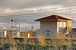
UPDATE:Thankfully it wasn't demolished; it has been moved to Moorooduc to become part of a railway museum.
|
|
I found some more images of Somerton station and the surrounding area on PROV. They have a very strange search system where if you do a main search you may not get back every result, or you only get partial listings. I asked them for assistance and was directed to another database:
http://proarchives.imagineering.com.au/index_search.asp?searchid=41
This one from 1899 clearly shows several buildings including the station, and possibly Somerton Road itself? If I've got my bearings right this would have been taken from the south-west corner of the crossing.
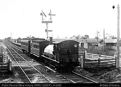
Click for full sized image: http://www.prov.vic.gov.au/images/12800/12800-00001-000095-010.asp
---
This one looks like it's taken high up (from a signal arm?), probably just south of Somerton Road with Campbellfield and Fawkner visible in the distance. Going on the loco I think it would be dated 1950 or later:
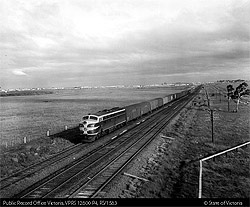
Click for full sized image: http://www.prov.vic.gov.au/images/12800/12800-P0004-000111-280.asp
There are 11 results in total, I won't link them all here.
|
|
Here's some search results that pertain to Somerton (at least a couple are new, never seen them before)
Somerton, 'Somerton Inn'
1946
record located in Sydney
barcode 3532551
Suspension of Fawkner Somerton train
1955
record located in Melbourne
barcode 3249489
Somerton - Post Office and related history
c1901 - c1988
record located in Melbourne
barcode 1351972
Somerton Post Office
1866 - 1986
record located in Sydney
barcode 3259112
I suspect the Somerton Inn record may be for a Somerton in a different state, or at the least the year is bogus (the date range is a rough guide and sometimes when you look at the record it's completely off). It is currently closed so I have submitted an application for access.
|
|
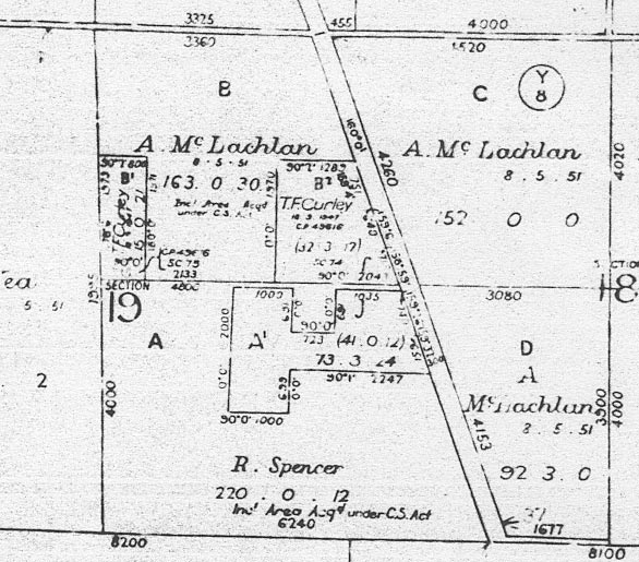
I noticed the 1960s Yuroke Parish map has a little section near Dunhelen Lane Yuroke that has a couple of unusually shaped blocks allocated to "T. F. Curley" and the text "Incl Area Acqd under C.S. Act." The years the land was allocated appear to be 1941 and/or 1947 (which is also unusual - most or all of the rest were in the 1800s) so perhaps that was some sort of returned soldier's scheme? (C. S. = Closer Settlement perhaps??)
I found reference to WWII enlistment records for a THOMAS FRANCIS CURLEY born 28 Aug 1914 in the national archives. If he were alive today he would be 93.
Does anyone know of this name? Just curious because it is an unusual and relatively recent entry on the map and seems to be exclusive to this one name.
There are also a few hits on Google for that name, in published books.
|
|
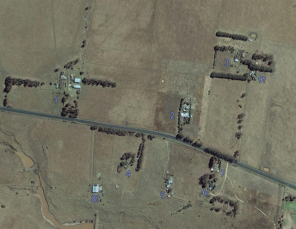
I was saddened a little the other day when I realised that a path lined with mature trees leading to a new playground (at Highlands, on the southern side of Craigieburn Rad) used to be someone's driveway. I guess it's better than just cutting down the trees.
Here's an aerial photo showing the cluster of houses around Craigieburn Road, I have given each one a number:
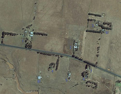
(Click for full sized image)
I count 7 separate properties, possibly 8 (looks like it has a separate driveway but it may be part of property #4). Property #4 is the one that has been replaced by a playground.
It appears property #7 was already demolished then, this may be a way to date the image. Could there have also been something immediately to the east of #3? Looks like a different parcel of land to #3.
If they're all separate then that would make it 9 properties that will be levelled soon...
UPDATE: Within a few days prior to 17th January 2008 property #5 was demolished. Only #6 and #2 remain.
UPDATE #2: House #6 was demolished in December 2008. Newspapers from 1906 were found underneath the wallpaper. A weatherboard property further west was also demolished around the same time.
|
|
I've found a collection of photos from a glider society that were based in Beveridge in the 1930s, wanted to find out more about where it was located.
http://www.nla.gov.au/apps/cdview?pi=nla.pic-vn3822540&referercode=cat
Some of the 90 photos show different locations but a large number are taken in Beveridge. Looks like they used Mt Fraser for launching.
|
|
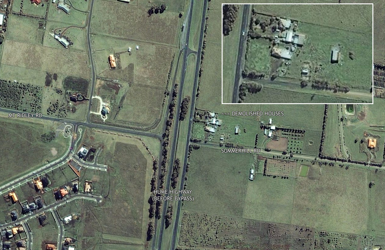
I came across an aerial photo service that had slightly stale (around 2003ish) photos available:
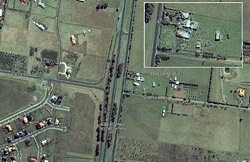
(Click for full sized image)
On the north-east corner of Hume Highway and Summerhill Roads were buildings demolished to make way for the bypass. This would have been where the Robert Burns Hotel originally stood. Looks like two distinct houses, one fronting the highway and one fronting Summerhill Road.
Even though the houses have been demolished and the land regraded there is still a portion of the land which appears to have been untouched (it still has a shed on it), so who knows, there may still be old coins lurking in the ground!
There was also a house slightly further south that was demolished. Can also see the farm complex that was demolished to create the newer area of Highlands off Craigieburn Road.
|
|
THE MELBOURNE MORNING HERALD, MONDAY, FEBRUARY 25, 1850
-------------------------------------------------------
Tenders required
TENDERS are wanted for the erection of a
National School House at Yuroke, near the
Somerton Inn, Sydney road, according to plans
and specification, to be seen at the temporary
school house, by applying to Mr. Tydeman the
secretary; any information regarding the same
may be obtained from the undersigned, to whom
tenders are to be sent, care of Mr. Vinge,
Somerton Inn, by or before the 11th March,
1850.
DANIEL MACKENZIE
Treasurer
Craigie Burn
14th February, 1850
|
|
From the Port Phillip Herald on August 14, 1840:
----
Four Farms on the Merri Creek for sale
by Private Bargain
No. 1, containing 175 ACRES
No. 2, containing 171 ACRES
No. 3, containing 158 ACRES
No. 4, containing 148 ACRES
Each of these Farms has an extensive frontage
on the Merri Creek, as well as possessing a water-
course intersecting two of the Farms and running
through a portion of the other two. They are
distant from Melbourne fifteen miles, with the
Sydney Road (as now permanently fixed) passing
through them. The soil is of excellent quality.
They are lightly timbered, and on each of the
Farms portions of land will be found without any
obstacle to the immediate commencement of farm-
ing operations.
Further particulars will be learnt by applying at
the office of
J. WILLIAMSON
Corner of Bourke and Queen streets.
-------------------------
15 miles from Melbourne, Sydney Road passing through, frontage to the Merri....... that's the eastern side of Craigieburn. I wonder if one of those farms was the
site that the Inn was built on at a later stage.
|
|
| 23 December 2007, 11:42am |
Did a little side project while I was waiting for the wood stain on the barbie to dry (any mistakes are probably due to inhaling fumes)
http://www.fadingvictoria.com/localhistory/somertonestate.html
Christine pointed this out to me a couple of months ago but I've now done a transcription. The first section is a lot of business banter but further down there's some really good descriptions of the area.
Merry Xmas everyone
|
|
Craigieburn and many other surrounding areas have plenty of old standing buildings, but I got to thinking: what is there in Somerton? The only "really old" ones I can think of are the Roxburgh Park Homestead (100+ years - now officially in the suburb of Roxburgh Park) and the warehouses at the former navy base (about 60-65 years - now officially in Greenvale)
The other question is whether Somerton has any residences remaining, and whether this is something unique (are any other suburbs in Melbourne purely commercial?)
I haven't been down every road in Somerton, but even so I can't recall seeing a building that was older than maybe 25-30 years max, and I've never seen a residence.
The Kernan house on the old Thirteen Mile Lane that CHIG visited still existed in 1991, so it was probably demolished later that decade as that area was developed as part of Roxburgh Park. I also came across an article that mentions Austrak purchasing "residential land" in the late 1990s to build their terminal. (They never responded to my polite request for any information about what was there before they developed the land.)
Can anyone think of anything "old" that's still standing within the borders of today's Somerton, which is bounded by Somerton Road, Merri Creek, Patullos [Thirteen Mile] Lane, and the railway line.
UPDATE: I finally remembered to email Hume Council and received a prompt response. Their reply is that there are no longer any residences on individual titles, although there may possibly be caretaker residences as part of a commercial property. The oldest remaining building in Somerton was built between 1968 and 1972.
|
|
I was at PROV today and had a quick look at the collection of directories before I left. I photographed a sample from 1915, 1935 and 1955 - here's what it says about Craigieburn:
1915:
CRAIGIEBURN--On Merri Creek with recreation hall, tennis and cricket
clubs, good fishing and shooting. Rail - 16 1/4 miles; fares, 1s 2 1/2d,
and 10d. Post and telegraph office. L. Watts, pm.
1935:
CRAIGIEBURN--On Merri Creek with post and telegraph office, recreation
hall, tennis and cricket clubs, good fishing and shooting. Coursing
enclosure (70 acres). Rail - 16 1/4 miles; fares 1s 9 1/2d, and 1s 2 1/2d.
1955:
CRAIGIEBURN--On Merri creek with post and telegraph office, recreation
hall, tennis and cricket clubs, good fishing and shooting. Church. Rail -
16 1/4 miles.
Just before closing I realised there was another bookshelf with the post-1955 directories in them - Craigieburn is still listed in the (final?) 1992 one, but I didn't have time to capture it... that's for another day.
BTW, Craigieburn does not seem to appear in the directory prior to 1907. PROV's collection goes from about 1885 to 1992.
I also came across an interesting document from 1852 which describes a request for right of way which is now part of Somerton Road. The map also shows Pascoe Vale Road marked as Old Sydney Road (these days it would be more like OLD OLD Sydney Road) and Mickleham Road is shown as Mount Gellibrand Road. I'm hoping to find some stuff like this for the Craigieburn area.
|
|
The latest planning system update includes reference to an amendment which will rezone the area known as Kalkallo Park in order to allow future industrial and commercial development.
The area affected is just over 1000 acres in size.
It looks like existing buildings of Kalkallo Park are still heritage listed ( http://www.hume.vic.gov.au/Files/KalkalloPark,Kalkallo.pdf ) but as to the rest of the thousand acres it's fair game. In the years to come the area north west of the Hume/Donnybrook Road intersection will look quite different, as well as the commercial development there's also a planned freeway interchange at that intersection.
More information is available here.
I think Kalkallo Park - or somewhere close anyway - was mentioned by Owen Laffan with regards to flax production during WWII. His name is mentioned as a reference in the heritage review pdf.
Kalkallo Park may also be the flax mill referenced in the Craigieburn Aerodrome proposal document - "A further site is probably available west of the Hume Highway and north of the Nineteen Mile Lane[3]. Owing to theerection of a flax mill on the site[4], which is now under construction, the site was not proceeded with."
|
|
A bit of trivia today, according to the Registrar of Geographic
Names, the recognised names for Aitken Hill are:
Aitken Hill (official)
Aitkens Hill (historical)
Mount Aitken (historical)
Yuroke (historical)
I've also seen it referred to as Mount Yuroke (perhaps they missed a word)
|
|
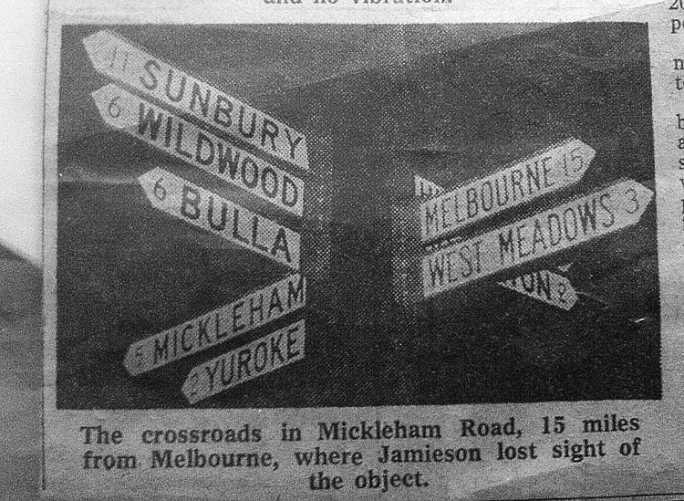
Does anyone remember this sign?

(Click for full sized image)
I can't remember the exact source of this pic but I think this was from a 1970s newspaper article about a UFO sighting.
My best guess based on the place names, direction and distances is that it was located at the junction of Somerton and Mickleham Roads. I think the bottom sign that is obscured says "SOMERTON" - any ideas what the top might say? It looks like it starts with "H" then possibly "I" or "L".
Does anyone remember this crossroads?
Here's a similar sign which still exists, at the western end of Craigieburn Road:
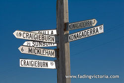
(Click for full sized image)
You can see where a sign was previously attached, just above "KONAGADERRA" on the right hand side. I wonder what it was?
On the other side of the "KONAGADERRA" sign (not visible in this image) you can see the number "2" underneath the current "3" - presumably an older sign with the distance in miles...
UPDATE: After seeing this image from 1956 it's apparent that the hidden sign at the top says "HUME HIGHWAY"
|
|
I'm a bit of a hoarder with documents, as I think that I may need them some day. I've been sorting through many of them today, deciding which ones to shred and which ones may still be required.
Some of them are not really important - such as an electricity bill from 1999 - but I thought it would be interesting to convert a small portion of them into digital format and save them for the future. It could be interesting for our kids or grandchildren in decades ahead to see a tangible address listed, or see how "cheap" it was to live in the 1990s and 2000s.
I also found a plan for a display home in Craigieburn that we based our
own on, and scribbled some notes on it to that effect.
I'm going to try and make a more proactive effort to document what is happening today, even though I may not find it interesting. Then again, sifting through some of my business records from the late 1990s brought back some memories...
So, don't throw out those old, unimportant documents indiscriminately! Choose a few to copy and save.
Don't forget my suggestion of documenting the mundane... take a pic of what's in your shopping bag, or the contents of your garage. It could be of much interest in later years.
-------------------------------------
Wouldn't it be great if there was a long term archive service for the general public? You could submit your documents and specify when they're to be released, and to whom. In these days of digital everything storage of a large number of relatively irrelevant documents would not be a logistical nightmare like it would be with paper. The documents would also be indexed electronically so that a search would involve a few seconds at a computer rather than accumulating documents over days, weeks, even years from multiple sources.
I don't know if it could ever happen, as there would be issues with privacy and ultimately the survival of the service for long enough to be of use. I can dream...
For now I'm going to start my own little paper folder, with an electronic copy. So far I've got:
- A receipt for a hard drive purchase
- A tag that was placed on my camera when it was repaired at Canon
- A rates notice for our land when it was undeveloped
- An invoice for some couches which kept breaking
- A credit card statement from 2004
- A few electricity, gas and water bills
- An order to install a second phone line at this house
- A business invoice from Telstra Internet showing billing errors (very common) and the scary amounts of money I paid them every month in the late 1990s
- Another business invoice from Telstra showing a typical phone bill from the same period, again with numerous errors
All of this is relatively recent as I only moved out of home and started fending for myself about 12 years ago. The business invoices have a bit of sentimental value (I wound up the ISP in 2001) but the rest of the documents are probably quite uninteresting at the moment.
|
|
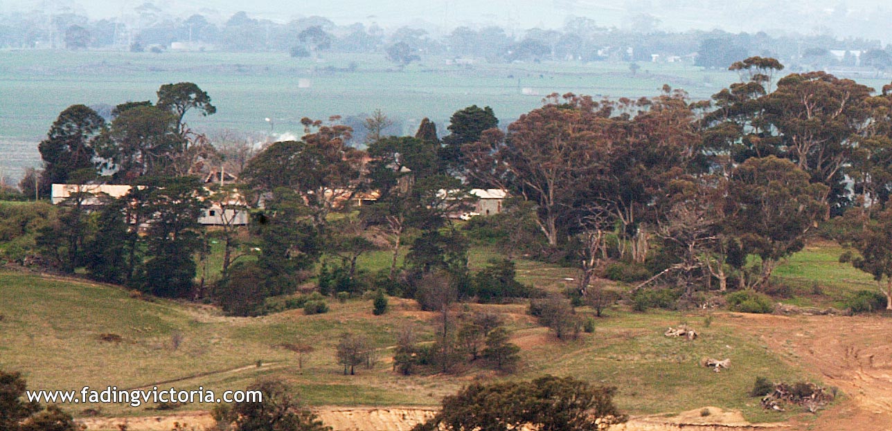
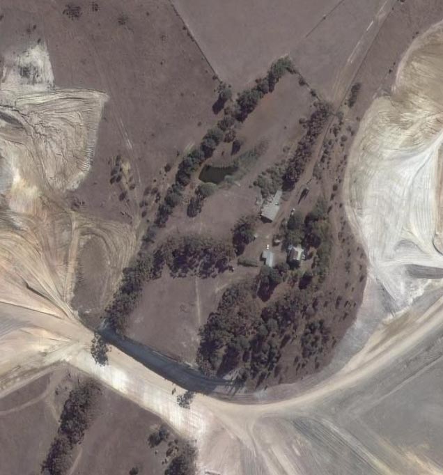
I visited with my camera, anyway. I was 3km away at the summit of Mt Ridley with a zoom lens, and back at home managed to find where Summerhill was hidden within the image:

(Click for full sized image)
This is at the very limit of my camera sensor and lens so I couldn't get in any further, and I had to do some extra fiddling to bring out sufficient detail. I'm pretty sure the main house is slightly left of centre; you can see a rusty verandah with bluestone above and to the right, and a rusty roof. Unfortunately much of it is obscured by trees.
I noticed today in the aerial photos from Google Earth that the quarry cutting is getting *incredibly* close to the Summerhill buildings. The distance between the rear of the main building and the closest cut is less than 70 metres.
|
|
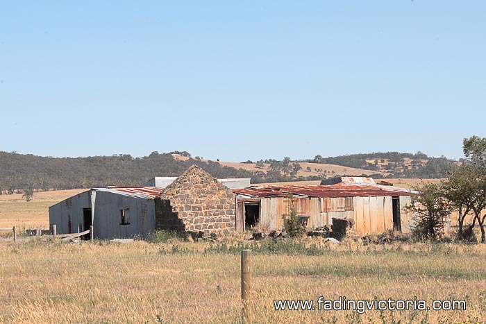
I found a photo of the Inverlochy Castle Hotel in the book "Pretty Sally's Hill: A History of Wallan, Wandong, and Bylands" by J. W. Payne.
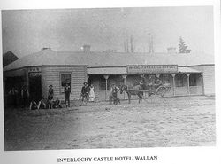
(Click for full sized image)
What it looks like today:

(Click for full sized image)
If you look at the first photo, to the very left there is a high pitched roof to the rear of the weatherboard hotel which could possibly be the bluestone ruins that are still there today. Stables perhaps?
|
|
Here's something I found in Pretty Sally's Hill: A History of Wallan, Wandong, and Bylands:
"Under this Act, the Sydney Road became the North-Eastern Highway on 1
July 1925 but that title was shortlived. On 17 October 1928 the Victorian
and New South Wales Governments jointly named the former Sydney Road the
Hume Highway."
[...]
"The last link in the chain was the modern thirty-four kilometre link
between Wallan and Broadford, [...] Designated the Hume Freeway, it was
declared open by the Premier of Victoria, the Hon. R. J. Hamer, on 3 May
1976."
So it appears the Hume Highway came into official existence in 1928, and the first portion of the Hume Freeway in 1976.
UPDATE: The portion between Craigieburn and Donnybrook is the last remaining portion of the "highway" and as of 2008 is being upgraded to "freeway" status.
|
|
|